- Silk Road 18: Murghab, Tajikistan
- Silk Road 19: More Murghab & Alichur, Tajikistan
- Silk Road 20: Langar, Bulunkul Tajikistan; Sept 2019
- Silk Road 21: More Langar & Ishkashim, Tajikistan; Sept 2019
- Silk Road 22: Khorog, Tajikistan; Sept 2019
- Silk Road 23: More Khorog, Tajikistan; Oct 2019
- Silk Road 24: Dushanbe, Tajikistan; Oct 2019
- Silk Road 25: More Dushanbe, Tajikistan; Oct 2019
Silk Road 18: Murghab, Tajikistan; Sept 2019
After the cold night in the yurt at Lenin peak, we awoke in our yurt, did our business, had a quick breakfast, and left to drive onto Murghab in Tajikistan.
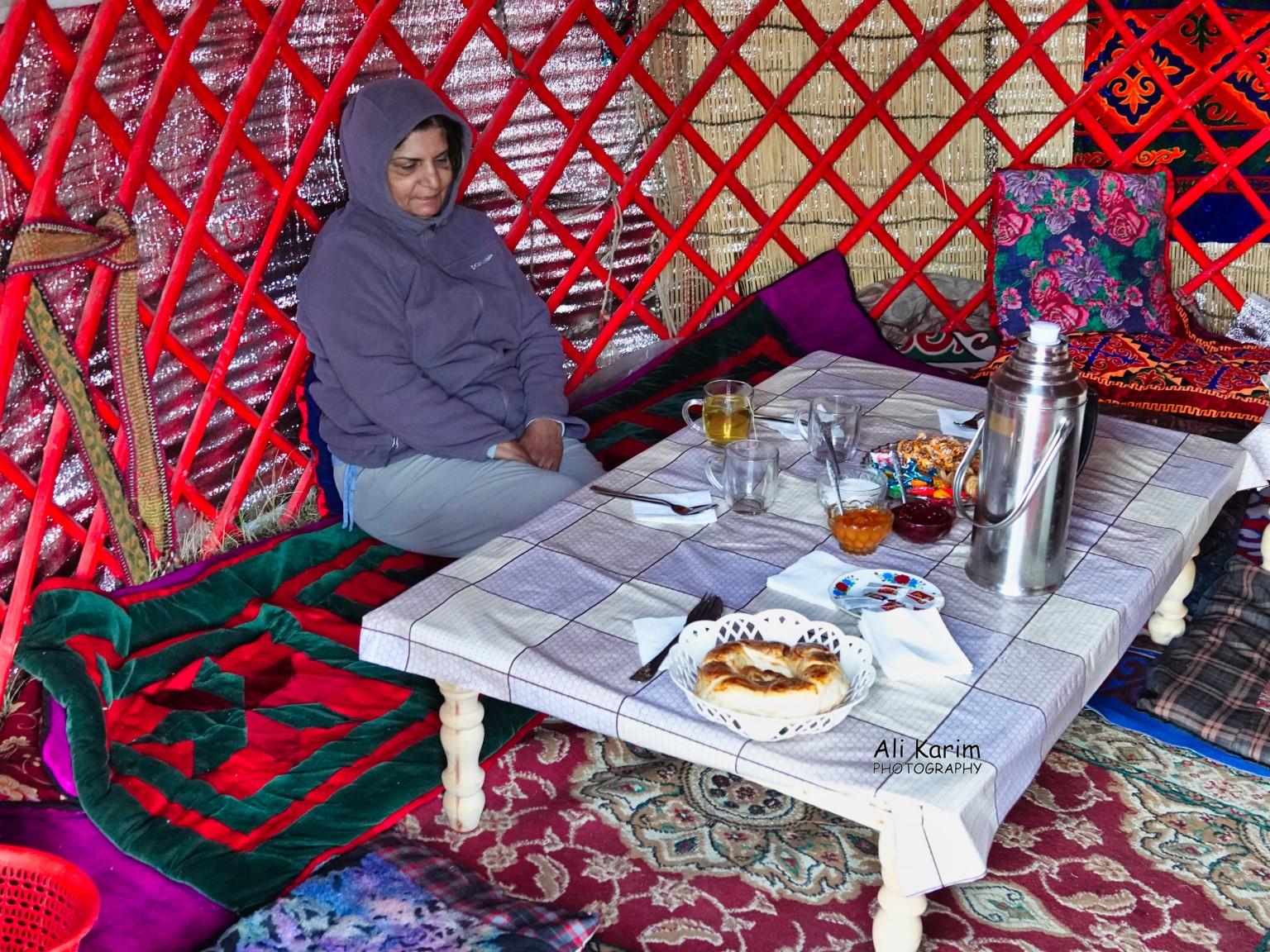
We did not have a very comfortable night, because it got cold at night outside (-10C), and our heater stove had run out of fuel in the night, meaning it got cold inside the yurt. It was also our first day at this high altitude of 12,000ft, low oxygen environment, and we were trying to fight off the altitude sickness and we were not used to the cot-beds. Not complaining, as we did this out of our choice, and the experience was well worth it; sleeping in a yurt under the massive Lenin Peak. I try to highlight all experiences; good and bad 🙂
We said goodbye to the other patrons, and drove the 25kms dirt track back to Sary Mogul, the nearest village.


At Sary Mogul, Ahmedali drove us to Erali’s mother-in-law’s house. Apparently, Erali’s wife’s mother lives here, and Erali’s wife, Aitolkun, had brought their daughter, Alia, to visit grandmother.

Aitolkun’s mother had laid out a lavish breakfast for us, complete with Sher chai 🙂

After this second breakfast and spending some time with Aitolkun (who spoke good English), we said our goodbyes, and left to go back to Sary Tosh, from where we would head into Tajikistan. We drove almost all the way back to Sary Tosh, and just before the town, we turned right, and headed south towards Tajikistan.

We soon arrived at the Kyrgyzstan border post

Ahmedali and Sherali went inside the border post, and took care of all formalities and we were soon on our way. Turns out, there is a 25km distance from here to the Tajikistan border post; effectively creating a no-man’s land buffer zone between Kyrgyzstan and Tajikistan. Since we had been at this high altitude, we had not seen any trees, as we were above the tree line. And the vegetation was mostly scrub. Some images below, in this no-man’s land


Views of Kyrgyzstan and Tajikistan at Kyzl Art
This Kyzl Art (Red Pass) was at 14,048ft, which was still 1,300ft ft below the Khunjerab Pass between China and Pakistan at 15,397 feet

About a mile after this pass, we reached the Tajik border post, where Ahmedali took care of the formalities (immigration and customs (currency, food, weapons, alcohol/tobacco, flora/fauna)). We had gotten our visa’s for Tajikistan for $25 each online beforehand, with an additional $50 each for entering the Gorno-Badakhshan Autonomous Region (GBAO) of Tajikistan; which we were in now. At the very last customs stop before the final gate, a guard called out and asked where we had got the hat (the topi that Alifbek had gifted me in Osh, that I had left visible on our vehicle dashboard). I told him it was from the Ismaili Khalifa in Osh, and the guard, who turned out to be an Ismaili, had recognized the distinctive Pamiri hat, and welcomed us to Tajikistan 🙂 . Nice start to Tajikistan.
A little bit about Tajikistan. The territory that now constitutes Tajikistan was previously home to several ancient cultures, starting with the Neolithic and the Bronze Age, and was later home to kingdoms ruled by numerous empires and dynasties, including the Achaemenid Empire, Alexander the Great, Sasanian Empire, Hephthalite Empire, Tibetan empire, Chinese Empire, Samanid Empire, Mongol Empire, Timurid dynasty, the Khanate of Bukhara, the Russian Empire, and subsequently the Soviet Union. Within the Soviet Union, the country’s modern borders were drawn when it was part of Uzbekistan as an autonomous republic before becoming a full-fledged Soviet republic in 1929.
In 2011, Tajikistan ratified a 1999 deal to cede 1,000 sq km (390 sq mi) of land in the Pamir Mountains to China, ending a 130-year dispute, and the relinquishing of China’s claims to over 28,000 sq km (11,000 sq mi) of Tajikistan territory. In 2012, the region saw a series of clashes between the Tajik military and militants loyal to former warlord Tolib Ayombekov after the latter was accused of murdering a Tajik general, and of drug trading. So a tumultuous history in GBAO.
The population of Tajikistan is just under 10M and 98% are Muslims, mostly Sunni Muslims. The GBAO region covers all the eastern part of Tajikistan, and borders the Xinjiang Uyghur Autonomous Region of China in the east, the Badakhshan Province of Afghanistan in the south, and Osh Region of Kyrgyzstan in the north. The region is mostly mountainous, the Pamir mountains which are known as the roof of the world, and three of the five 7,000 meter summits in formerly Soviet Central Asia are located here, including Ismoil Somoni Peak (formerly Communism Peak, and, before that, Stalin Peak; 7,495 m), Ibn Sina Peak (formerly Lenin Peak, and still known by that name on its Kyrgyz flank; 7,134 m), on the border with Kyrgyzstan, and Peak Korzhenevskaya (7,105 m). GBAO makes up 45% of the land mass of Tajikistan, but has only 3% (or roughly 300,000) of its population living here; they are mostly Pamiris, as the Ismaili’s are known here; though there is a decent size Kyrgyz population, especially closer to the Kyrgyz border that we had just crossed.
Three major routes of the Silk Roads ran through present day Tajikistan. These ancient routes were mentioned in contemporary Persian, Greek, Chinese and Arabic sources which highlighted Tajik contributions to the commerce and culture of the time, especially between the 5th and 12th centuries. The first route was the Sogdian, or North route between Samarkand (UZ) and Kashgar (CN); the second one was Karategin route between Termez (UZ) and Kashgar (CN) and the third one was Pamir route linking Balkh (Afghanistan) and Tashkurgan (CN).
We were now in GBAO Tajikistan, and the altitude was about 4,200m (or 13,800ft) consistently. The region was arid, almost completely devoid of vegetation; a high altitude desert, as this area was consistently above the tree line. The word “Pomir” is supposed to mean “the roof of the world” though some claim it means “feet of the sun”. Some images below of the Pamirs in Tajikistan

Views of the landscape on the Pamir mountains

We soon arrived at Karakul (Kyrgyz for Black Lake) Lake, not to be confused with the Karakul Lake in Xinjiang, China, both are high altitude basin lakes, meaning they are in a basin, and have no outlet. They get filled from snow melt, and evaporation leaves behind salt and mineral deposits; the lakes getting saltier each year.

Views of Karakul Lake


We soon arrived at the small town of Karakul, which was a collection of small houses on the edge of the lake; not sure what the sustenance of the village was, as the lake has little life, and the land is a high altitude highland desert. The wooden poles once used to carry electricity and telephones wires to the community, built in the Soviet days, but now unused and in a state of disrepair. We stopped here for lunch at a home stay.


Since there were no trees here and the electricity supply was no longer working, I asked what they used for heating/cooking fuel.
I was shown this kind of scrub below, which I later researched to be Teresken. Unfortunately, this scrub takes a long time to mature, and with the lack of electricity and trees, this scrub is being “harvested” to the extent that it is becoming scarcer and scarcer over time. Most unfortunate.

After lunch, we said our goodbye’s and left Karakul and started driving towards Murghab, our first overnight in Tajikistan. Some scenes along the way


View at Akbaital (white horse) Pass


We soon arrived at Murghab, from the Persian word margh-ab meaning “prairie river”. Murghab is the capital of Murghob District in the Pamir Mountains of Gorno-Badakhshan Autonomous Region, Tajikistan. With a population of 4,000, Murghab is about the only significant town in the eastern half of Gorno-Badakhshan Pamir mountains. It is the highest town in Tajikistan at 3,650m or approx. 12,000ft. elevation. The population is 85% Kyrgyz (due to closeness to Kyrgyzstan) and 15% Pamiri (Ismaili’s). We drove to the family’s guest house (Erali’s family) where Sherali, Ahmedali and the parents live. Ahmadali and Sherali were all glad to be home with their families 🙂 . Accommodations were basic but decent, and they did have the luxury of an indoor western flush toilet, and hot showers 🙂 ; oh how we take these things for granted in the western world 🙂
Our trip so far


Next, more on Murghab, and then onto Alichur and beyond.
This entry was posted in Asia, Silk Road Tajikistan Sept-Oct 2019, Tajikistan
Pingback: Silk Road 19: More Murghab & Alichur, Tajikistan - Ali Karim Travelog Asia
Pingback: Silk Road 17: Lenin Peak & Turpal kul, Kyrgyzstan - Ali Karim Travelog Asia
Great historical and geographical summary.very informative.
You really experienced the real life these guys live.
My trip to Tajikistan was very different. I did not have all these wonderful experiences. Mine was a well orchestrated trip with all the conveniences.
Mahamud, thanks for the feedback. We do try and experience things like the locals for the short time we are there.
I am sure their lives are much rougher, which is very sad. But it gives us great experiences, exposures, & and a lot of thankfulness for the good lives we have in the west that we would not otherwise have had. We are indeed blessed to be able to do all this
Ali, really enjoyed your blog on Kyrgistan/Tajikistan
You two are so brave to stay in a yurt Shiraz has
expressed a desire to stay in one overnight, but I
absolutely refuse I cannot rough it that much
Thanks Shahida, for the feedback. Yes, yurt living is not easy. But they do have luxury yurts for tourists; but we decided to rough it this time 🙂
Wow! Glory to God – fantastic blog very interesting experience and useful information and beauty of mother nature.
Thanks for sharing time and knowledge.. Enjoy.! You both deserve the best.
Best regards,
Shamim.
Thanks Shamim for the nice feedback; so glad you are enjoying traveling with us, and the beauty of mother nature 🙂
Awesome adventure and wonderful write-up, Ali.
Congratulations and Kudos to our incredible, intrepid travelers!
Keep up the travel, photos, stories and blog!
Good luck and best wishes,
vineeta
Thanks Vineeta for the feedback; so glad you are enjoying them 🙂
Loved every image and a great write up. Stay blessed.
Love to Dilshad.
Thanks Muslim, for the nice feedback.
Once again most informative. Where next? Thailand and Vietnam? Good luck
Thanks Mohammed; glad you found the blog informative.
No travel plans currently; waiting to see how the Corona Virus situation develops 🙁
Hi Ali – again an excellent and informative write up on the “Roof of the World.” I could not but relate this part of the world to the altitudes of Nairobi, Kenya and the Highland region around Limuru which were at approx. 5,500 – 6,000 feet, approximately half the height level you were at on this trip. And we used to consider those parts as high altitude!! The terrain in the pictures is very similar to that one observes in the pictures at higher altitudes – that is, at greater than 10,000 ft, of climbers going up Mt Kenya or Kilimanjaro in East Africa. So from the “Roof of Africa” to the “Roof of the World”!! Well written article.
Thanks for the feedback, Zahir. Appreciate the kind words
Thanks for sharing!
Thanks Amir
Beautiful pics and videos. Recently I was watching Genghis Khan Netflix movie in which I had notice similar view of large open barren lands, the lambs, the folks.
May God keep you safe in your journeys now and in the future. Ameen.
Aziz
Thanks Aziz, for the feedback; much appreciated. And thanks for the prayers; we all need them
Thanks for sharing,i wish i can follow you on the trip.
best regards.
Lin
Thanks Lin, for the feedback.
Hello Ali,
How are you?
How is your family?
Thanks for posting very useful information and helpful advices for travelers.
Thanks for posting us can I use some pictures and information from your website?
And can you send me my daughter’s and wife’s photos??
Best regards,
Erali
HI Erali, we are all fine. Thanks for the feedback; I certainly hope this helps you and others for tourism
Yes, of course you can use the images from my blogs. And I have sent you the pictures of Aitolkun and Alia separately by email.
Enjoy.
Fantastic blog as usual. So many interesting things to see and experience. Very informative of that part of the world where one would not contemplate to travel. Quite inspiring. Keep up your adventures and look forward to reading more.
Alnoor, thanks so much for the kind words. So glad that you are enjoying my blogs 🙂
Appreciate that
Great blog Ali. Fantastic photos! Have been to Murghab from the Tajik side and could relate. All the best for the rest of the trip..
Thanks Anil for the feedback and the good wishes. Glad you enjoyed the blog and hope it brought back great memories
Brave couple. My wife and I went up to 11,000 feet high mountain in Maui, Hawaii; my wife was gasping for Oxygen. Paramedics helped her, and we were told to rush down to 6,000 feet, before a possible heart attack happens!
U guys did awesome O M G .
What a scary experience Abdul; thanks or sharing this with us. We are thankful that we did not have any such experience out there, as it was very remote with few medical facilities available nearby.
Stay safe